


“I never imagined the day would come that I would be witness to a wall passing through the depths of my land. In all of the occupation’s forms, I never imagined I would helplessly watch as my land was destroyed.” [1]
–Abdel Nasser Quzmar, Palestinian Farmer
Fact Sheet:
Israel’s goal in building the “security” wall is twofold: (1) to confiscate Palestinian land in order to facilitate further colony expansion and unilaterally redraw geopolitical borders and (2) to encourage an exodus of Palestinians by denying them the ability to earn a living from their land, by denying them adequate water resources, and by restricting freedom of movement to such extent as to make remaining in the town or village an unviable option.
The first phase of the wall’s construction is complete. If the wall were truly about security, the wall would have been built on Israel’s 1967 pre-occupation border (the “Green Line”). However, the wall is not being built on the Green Line, but rather well within Occupied Palestinian Territory.
The Case of Zayta – “Correcting” the Border
For an accompanying map, see http://www.nad-plo.org
/maps/focuszayta903.pdf
* Located near the Green Line, the town of Zayta has a population of approximately 3,000 Palestinians.
* The town of Zayta originally extended into what is now Israel. In 1948, most of the town’s agricultural lands were seized by Israel. The Israeli town of Maggal and parts of Hadera are now situated on Zayta’s land.
* Following Israel’s military occupation in 1967, 68 homes, a school and a medical clinic were destroyed by the Israeli Army. Many of the town’s residents fled and they have never been allowed to return.
* The residents of Zayta earn their living primarily from selling agricultural produce. Zayta exports 80% of its produce to the Occupied West Bank. Two-thirds of the residents rely upon food distributions from the Red Cross, a significant increase since 2000.
Effects of the Wall on Zayta
According to Israeli military orders, [2] the construction of the wall is meant to “correct the border” (i.e. alter the Green Line). The result is the confiscation of Palestinian land, while ridding the land of its Palestinian owners.
* The Israeli Army has built a militarily-fortified barrier that has separated the northern and southern agricultural sections of the town from the town center. Of the 875 dunums [3] of land that are isolated west of the wall, 443 dunums of agricultural land have been confiscated by Israel, in what the Israeli Army terms a “ border correction ." More than 500 of Zayta’s residents have lost their land and means of livelihood.
* As part of the strategy to contain densely populated Palestinian areas by creating “depth-barriers” (smaller, fenced-in Palestinian areas that are immediately adjacent to the larger Palestinian canton area), Israeli military authorities issued military orders on May 15, 2003 [4] which stated that they would “put their hands on” an additional 300 dunums of Zayta’s prime agricultural farmland in order to erect a new portion of the security wall, closer to the Green Line. Now Zayta villagers will be separated from their land by one portion of the security wall and their land will be sandwiched between the first and second portion of the security wall. If the second portion, closer to the Green Line, had been erected instead of the first, then the villagers would still have access to their agricultural lands.
* The villages of Nazlat Issa and Baqa Sharqiya, with approximately 4,500 people total, will be trapped between these two walls. Nazlat Issa has been particularly hard-hit by Israel’s destruction policy. In January 2003, 63 shops/business stalls in Nazlat Issa’s central market were demolished. On August 21, 2003, an additional 115 shops/business stalls were demolished as well as seven homes. Nine additional homes have been served with demolition orders. On August 24, 2003, Israel issued confiscation orders for 16 dunums in the heart of Nazlat Issa’s central market. [5] The order was issued “pursuant to the current special security conditions in the area that require the defense of Israeli settlements . . .”. The nearest Israeli settlement is Homesh, approximately 6-7 kilometers away.
* One Zayta resident, Zikrallah Aqad, 75 years old, married with four children and owning seven dunums of land, is trapped between the two walls, isolated from the rest of the homes in Zayta. In May 2003, his access road to the town was cut off and now he must travel eight km by horse and carriage in order to reach his village, even though the direct route to his home is only a few hundred meters. His four school children will be forced to live in their aunt’s home, on the other side of the wall, in order for them to attend school this year. In July 2003, the Israeli Army cut Mr. Aqad’s electricity.
* More than 6,000 of Zayta’s olive trees have been uprooted to build the wall.
* Homes situated within 35 meters of the wall (what Israel terms a “buffer zone”) are at risk of demolition.
1 THE PALESTINIAN ENVIRONMENT NGOS NETWORK (PENGON), STOP THE WALL IN PALESTINE 111 (2003).
2 Israeli Military Order 02/18/C.
3 1 dunum = ¼ acre.
4 Military Order H/36/03
5 Military Order 03/57/C
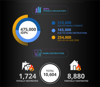
Israeli Assault on Gaza By Numbers in 30 Days
Date posted: August 09, 2014
By Safa Agency